Tornado Forecasters Mark Golden Anniversary
June 15, 1998

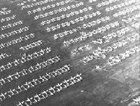
A tornado swept through Tinker Air Force Base on March 20, 1948, resulting in millions of dollars in damage.
"You are about to set a precedent," said General Fred S. Borum. The date was March 25, 1948. Borum, commander of the brand-new Tinker Air Force Base, near Oklahoma City, was speaking to two young meteorologists, Major Ernest Fawbush and Captain Robert C. Miller. The weather watchers had just told him that the weather charts looked awfully similar to those of five days earlier, when a tornado ripped through Tinker, causing millions of dollars in damage.
"Are you going to issue a tornado forecast?" Borum had asked, to which Fawbush and Miller had nervously replied, "no one has ever issued an operational tornado forecast."
Fifty years later, tornado warnings are one of the familiar rites of spring---thanks in part to the precedent set in 1948. To celebrate the golden anniversary of the historic event, meteorologists and severe storm specialists from across the country gathered in March at the University of Oklahoma for three days of special events. Speakers at a day-long symposium held on March 24 described various aspects of tornado forecasting, including efforts to understand storm dynamics by means of mathematical modeling.

Weather charts strikingly similar to those of March 20 led Tinker meteorologists to issue the first-ever tornado forecast, on March 25, 1948, for the same location. The forecast was accurate; although the tornado caused plenty of damage, emergency precautions had been taken and the forecasters became "instant heroes."
If meteorologists ever realize their dream of forecasting tornadoes in precise locations, experts agree, key contributions will come from mathematical techniques for tracking the creation of severe storms and handling the massive computations that appear unavoidable in numerical weather prediction. Mathematics is an integral part of the forecaster's art, and modeling has already proved valuable in the purely scientific endeavor to understand storm formation and dynamics.
The F-Word
Fawbush and Miller's bold forecast was spectacularly accurate. At around 6 P.M., a squall line moved in from the southwest. As the line approached Tinker, "two thunderstorms seemed to join and quickly took on a greenish black hue," Miller wrote later. There was "a slow counterclockwise cloud rotation around the point at which the storms merged. Suddenly a large cone-shaped cloud bulged down, rotating counterclockwise at great speed." The wing of a mothballed B-29 "floated lazily upward toward the visible part of the funnel. A second or two later, the wing disintegrated, the funnel shot to the ground, and the second large tornado in five days began its devastating journey across the base, very close to the track of its predecessor."

"The close knit world of the tornado and severe thunderstorm forecaster often seems somewhat demented to those not knowledgeable in this discipline. This apparent derangement is based on our seemingly ghoulish expressions of joy and satisfaction displayed whenever we verify a tornado forecast. This aberration is not vicious; tornadoes in open fields make us happier than damaging storms and count just as much for or against us. We beg your indulgence, but point out the sad truism that we rise and fall by the blessed verification numbers. There is a fantastic feeling of accomplishment when a tornado forecast is successful. We are really nice people but odd."-Robert Miller, 1948 tornado forecaster, writing in the 1970s.
The tornado of March 25 did plenty of damage. But because of the forecast, emergency precautions had been taken, including the diversion of incoming air traffic and the movement of base personnel to places of relative safety. (During the earlier tornado, men in the control tower had been badly cut by shattered glass.) "We became instant heroes," Miller wrote. The denouement was distinctly different from what he had imagined earlier in the day, after issuing the forecast: "I wondered how I would manage as a civilian, perhaps as an elevator operator. It seemed improbable that anyone would employ, as a weather forecaster, an idiot who issued a tornado forecast for a precise location."
Indeed, the odds of two tornadoes tearing through the same piece of real estate within a week are inestimably small, says Robert Maddox, who was director of the National Severe Storms Laboratory (NSSL) from 1986 to 1996 (and who worked with Miller in the early 1970s). The fact that the storm behaved exactly as they had said it could "allowed Fawbush and Miller to move ahead quickly to develop and refine their embryonic forecast techniques for severe weather," Maddox says. Had the second tornado failed to materialize, "full acceptance and the national implementation of severe weather forecasting, on both the military and the civilian side, would probably have happened a lot more slowly." The famous forecast involved "a remarkable confluence of personalities, skill, interest, and, in looking back, unbelievably extreme good luck."
It's hard to imagine a time without tornado warnings, but for decades the official policy of the U.S. Weather Bureau forbade any mention of the F-word (that's Funnel). Forecasters were allowed to suggest the possibility of "violent local storms," but not "tornadoes." The prohibition extended to record keeping: The official weather history of Kansas, for example, lists not a single tornado from 1897 to 1913!
It wasn't always so, points out Steven Weiss, a meteorologist at the Storm Prediction Center in Norman, Oklahoma. In the 1880s, John Finley of the U.S. Army Signal Corps was sent to survey tornadoes in the Midwest. He began by compiling a historical record, of 600 tornadoes from 1794 to 1881, and organized a system of volunteer tornado reporters. (The demands of the job got to him in 1882, when Finley suffered a nervous breakdown. According to his doctor, "He is doing too much brain work.")
In 1884, Finley began to make experimental tornado predictions. He divided the Midwest into 18 regions, and made tornado forecasts for each region each day from March through June. Each forecast was a simple Yes or No prediction: There either would or would not be a tornado somewhere in the given region during the day. (Actually, for March and April, he made two eight-hour predictions each day, at 7 A.M. and 3 P.M. For May and June, he made a single, 16-hour prediction at 7 A.M.) Most important, Finley kept a careful record of his forecasts' accuracy.
In 1886, Finley wrote up the results of his study. His predictions, it turned out, had been correct 96% of the time. As a critic of the report pointed out, however, Finley would have been even more accurate---98%---had he simply never predicted any tornadoes at all! As statisticians will attest, judging the success of rare-event predictions is a tricky business. Nevertheless, Finley had established a basis for future tornado forecasters. In particular, he cited the need for analytic techniques to compensate for the sparsity of observational data---an aspect of numerical weather prediction that is as true today as it was a hundred years ago.
Finley's predictions were discontinued in 1887, after an embezzlement scandal within the Signal Corps prompted the removal of the weather service from its jurisdiction. The nation then entered what Weiss calls the "Dark Ages of tornado forecasting." The Weather Bureau (renamed the National Weather Service in 1970, when it moved again, from the Department of Agriculture to the Department of Commerce), looking to avoid panic, adopted an official policy of not warning the public of possible tornadoes. The ebb in official interest in storm prediction continued until the 1940s.
With war on the horizon, Weiss says, the people in charge of munitions plants suddenly got very interested in understanding the nature of lightning storms. In 1943, the War Council on Meteorology requested information on tornado forecasting. The military's increasing expertise in severe weather culminated in the 1948 tornado forecast at Tinker. It was another four years, however, before public pressure forced the Weather Bureau to begin issuing civilian tornado forecasts. (The first, on March 17, 1952, was a bust: No tornadoes were reported.)
Shear Beauty
Scientific as the early forecasters tried to be, their methods were still more art than science, in part because tornado dynamics were not well understood. Things began to change in the 1970s, says Louis Wicker, a professor of meteorology at Texas A&M University. Tornado modeling finally took off (or touched down). The reason is fairly simple, Wicker says: "Computer power became sufficient to actually tackle the three-dimensional computation."
In 1978, Joseph Klemp of the National Center for Atmospheric Research and Robert Wilhelmson of the University of Illinois developed a three-dimensional model that enabled them to perform realistic computer simulations of storms. Their simulations produced such features as the hook-shaped precipitation pattern that is familiar from Doppler radar images. (A hook echo is often cited as reason to head for the basement. A picture of the pattern seen on a radar screen during the 1974 tornado that wiped out Xenia, Ohio, caused even the experienced audience at the minisymposium to gasp.) The Klemp-Wilhelmson model is still the basis for much of the work being done in tornado dynamics.
Mathematically speaking, a tornado is vector calculus with a vengeance. Severe storms bubble up in a witch's brew of two scalar fields---pressure and humidity---and a vector field known as wind. These elements conspire to produce a moist mass of rotating air, which meteorologists have taken to calling a "supercell." The term was coined in the 1960s by British meteorologist Keith Browning, who proposed a theory describing how updrafts become tilted and start to rotate in what's called the mesocyclone. Roughly speaking, wind near the ground tends to come from the southeast; moving upward, the wind shifts, coming from the south at a half mile and from the east at a mile. It's the rotational shear that creates the possibility of tornadoes, which concentrate energy much as an ice skater turns a slow spin into a blur by pulling in her arms.
The equations that describe storm dynamics are not unduly complicated. For the most part, they represent the usual conservation laws for mass and energy, with angular momentum taking center stage. The equations for, say, the inner workings of a petrochemical plant can be more baroque. What makes tornado equations more difficult to deal with is the scope of the problem: A supercell can be tens of kilometers across; the tornado itself can dwarf (not to mention destroy) a manufacturing plant. And unlike a manufacturing plant, which has been engineered to an unnatural stability, severe weather is inherently turbulent.
These features are severe challenges for numerical storm modeling, says Kelvin Droegemeier, a professor of meteorology and director of the Center for Analysis and Prediction of Storms at the University of Oklahoma, one of the original NSF Science and Technology Centers, now in its ninth year. "Everything is moving toward higher resolution," he says, but the problem is, "the further downscale we go, the less we know" about key physical parameters. For example, the interaction of the atmosphere with features on the ground---a wheat field, say, or open water---is clearly important but largely unexplored.
There is also the perennial problem of gathering data: Weather stations are still widely scattered, making it tough to initialize a numerical model based on a fine grid. (Furthermore, observations are made at different times and often contain different types of information, so it's a daunting task just to assimilate the data that do exist.) The new generation of Doppler radar stations, NEXRAD, which came on line in the 1990s, provides far more information than John Finley ever dreamed of, but putting those data to use is another question. "We have a lot of small-scale information available, but we have to use those data effectively," says Droegemeier.
Finally, it's uncertain how accurate any tornado-forecasting model can ever be. "We're really compelled to establish the fundamental limits of predictability," Droegemeier says. "What really is predictable?"
Current models do a good job of forecasting the overall timing and structure of storms hours in advance, Droegemeier points out. That's a huge scientific advance, and one that has huge economic significance. But exact details are regularly wrong. No model is yet able to forecast a specific tornado, or even precisely where a storm will be most severe.
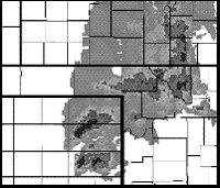
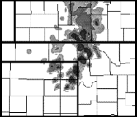
That's significant for, among others, the airline industry. It costs in excess of $100,000 to divert a commercial airplane from its intended destination. (Overall, bad weather costs the airline industry more than $2 billion a year.) Knowing in advance, for example, that a hailstorm will strike Will Rogers Airport from 5:00 to 5:15, rather than tracking 50 miles south a half hour earlier, would be awfully advantageous. That sort of detailed early warning doesn't look likely, but improved storm forecasts have caught the eye of at least one airline. The Center for Analysis and Prediction of Storms (CAPS) is now two years into a three-year research and development contract with American Airlines that seeks to apply storm-scale numerical prediction technology to commercial aviation. They now have a completely functional and fully automated prototype, delivering up to six forecasts per day and over 500 "products" (the usual pressure and temperature charts, plus such air-line arcana as icing and turbulence indices) every hour. (See Figure 1.) The system operates primarily over AA's hub airports at Dallas-Fort Worth and Chicago (hence the project's name, Hub-CAPS), but can be easily switched to other locations.


Figure 1. Observed (left) and predicted (right) reflectivities and surface wind fields from supercell thunderstorms, June 1995. (Courtesy of Hub-CAPS.)
Are These Guys Crazy?
One thing is already clear: You don't want to fly a plane into a tornado. There are, however, people who might think about trying. At the March symposium, Howard Bluestein of the University of Oklahoma and Erik Rasmussen of the National Severe Storms Laboratory described current and future field efforts in tornado research. A project dubbed VORTEX (Verification of the Origins of Rotation in Tornadoes Experiment) has been under way since 1994 to test specific hypotheses regarding tornado genesis and tornado dynamics.
The VORTEX field team goes trolling for tornadoes about 20 times each season (April, May, and June). The project is mainly ground-based but does have three planes for making Doppler radar measurements. The goal of the project is to collect an exhaustive data set for one storm per outing. In 1994, a "bad" year for tornado chasers, VORTEX caught up with nine storms in 18 excursions, none of which offered any opportunities for tornado measurements. VORTEX-95 had better luck: nine tornadoes among 13 storms, including four that were particularly large and violent. (The mission summary from June 8 notes that "South of Kellerville [Texas], the pavement was completely removed from highway 1443." Six days earlier, in Dimmitt, Texas, "A very heavy piece of [farm] equipment fell from the sky.")
Like the stormchasers in the 1996 movie Twister, the VORTEX researchers try to get equipment inside the tornado itself. That's a lot easier said than done. However, Rusmussen says, a somewhat nutty-sounding idea just might do the trick: The Army has suggested the possibility of "attacking" tornadoes with instrument-carrying surface-to-air missiles. Just as the aftermath of World War II led to the first tornado forecast, the aftermath of the Cold War just might lead to the first detailed look inside one of nature's most violent phenomena.
Barry A. Cipra is a mathematician and writer based in Northfield, Minnesota.

